Tag Archives: Nature

Kickem Jenny underwater volcano Grenada.

Kick ’em Jenny underwater volcano near Grenada.

What is Kick ’em Jenny?

Kick ’em Jenny is a submarine volcano located 8km north of Grenada.
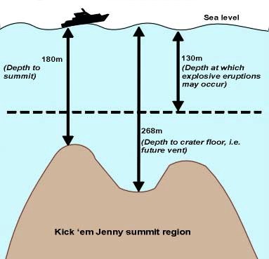
The volcano is about 1300m high, and its summit is currently thought to be about 180m below the surface of the sea.

Tsunami danger.

In addition to the vulnerability of the shipping industry many people are also concerned about sea waves or tsunamis.
While it is probable that large explosions or landslides at Kick ’em Jenny could generate tsunamis, the threat from tsunamis has been largely over exaggerated.
Not all eruptions at Kick ’em Jenny will generate tsunamis and not all tsunamis will be large.

As far as we know, Kick ’em Jenny is the only ‘live’ (likely to erupt again) submarine volcano in the Eastern Caribbean.
It is also the most frequently active volcano in the region, erupting at least 12 times since it was discovered in 1939.

The last eruption of Kick ’em Jenny occurred in December 2001.
The volcano is currently at Alert Level YELLOW and there is 1.5km exclusion zone around the volcano.

Kick ’em Jenny is also a modern day demonstration of how the volcanic islands in this region were formed.
With each submarine eruption deposits of volcanic material accumulate around the summit. All of the volcanic islands of the Lesser Antilles began as submarine volcanoes.
As an example from the northern hemisphere, Surtsey Island in Iceland formed in 1963 when a submarine volcano reached the surface of the sea.
Eventually, Kick ’em Jenny will form a new island in the southern Grenadines.

How deep is Kick ’em Jenny?

Between the 1960’s and the late 1970’s the depth to the summit of the volcano was approximately 180-190m.
In the 1970’s and early 1980’s the depth to the summit of the volcano decreased to approximately 150m, reflecting the growth of a dome within the crater.
This dome was destroyed during eruptions in the late 1980’s and a survey conducted by the U.S.-based National Oceanic and Atmospheric Administration (NOAA) in March, 2002 revealed that the summit is currently 180m below the surface of the sea.

Kick 'em Jenny is the source of a number of potential dangers.

Kick ’em Jenny is the source of a number of potential dangers.

Until recently it was thought that Kick ’em Jenny had grown 46m (from 236m to 190m below sea level) between the surveys of 1962 and 1966.
However, data collected from the two most recent cruises (March 2002 and March 2003) and a careful re-examination of data collected on even earlier cruises make it clear that the crater rim of Kick ’em Jenny has remained at the same depth below the surface (180-190m, within measurement uncertainty) since at least 1966.

The major sequence of changes over the past forty years has been that a dome grew in the crater between 1976 and 1978.

This dome collapsed in either 1988 or 1990 and there is now no trace of it left.
There is in fact a new interior crater about 30 metres deep on the site where the dome used to be so it is more accurate to say that the active vent area of Kick ’em Jenny has in fact become deeper.
Kick ’em Jenny has, therefore, NOT grown closer to the surface between 1962-2003.

During a research cruise in March 2003 scientists discovered three craters (C1, C2 and Kick ’em Jack) and two domes (D1 and D2) near Kick ’em Jenny.
Further investigations are needed to confirm whether these are separate ‘live’ volcanoes. Click on the image for a larger view.

Kickem Jenny underwater volcano Grenada.

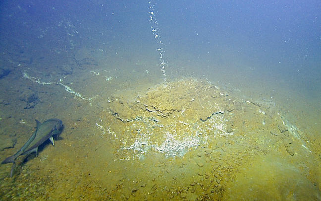
Underwater volcano Kick em Jenny.

Where is Kick ’em Jenny?

Kick ’em Jenny is located approximately 8km north of Grenada (12.18 degrees North, 61.38 degrees West).
This location is in the southern part of the Grenadine Islands which are themselves in the southern part of the Lesser Antilles island arc (see Map 1 below).
The volcano should not be confused with the nearby Diamond Rock, which is also called ‘Kick ’em Jenny’ on some charts.

On land the location is clearly visible from northern Grenada. From Sauteurs look towards the Île de Ronde. West – i.e. to the left – of the Île de Ronde is a small group of rocks called The Sisters.

Kick ’em Jenny is 1.6 nautical miles (about 3 km) due west of the Sisters or about as far west of the Sisters as the Sisters are of the Île de Ronde.

The depth from the highest point of the crater rim to the lowest point of the crater floor is about 80m.
The crater is breached to the northeast and contains an interior crater about 30m deep.
The summit sits within a much bigger horseshoe-shaped depression which extends at least 20km to the west of Kick ’em Jenny and widens from about 5km to 10km.
The depression contains a sequence of debris-flow deposits.


Useful information.

For persons planning to take sea vessels in the vicinity of Kick ’em Jenny.

Exclusion Zones.
The two most critical hazards regarding Kick ’em Jenny are the potential threats to shipping and the hazards posed by tsunamis.
Currently, the threat to the shipping industry is the more immediate concern.
Although the most obvious hazards are those directly resulting from an eruption, the volcano may also be dangerous to shipping during ‘quiet’ periods.

During an eruption, water near the volcano may become rough and the rapid ejection of hot rocks and ash can damage ships nearby.
However, during quiet periods between obvious eruptions, it is extremely likely that considerable amounts of volcanic gas escapes from Kick ’em Jenny.

If these bubbles become concentrated and the water density drops, any boat entering into the area will experience a loss of bouyancy and may even sink.
This possibility of lowered water density above the volcano is an ever-present hidden hazard.

For this reason scientists at the Seismic Research Unit, in collaboration with the government of Grenada, have instituted a 1.5km exclusion zone around the summit of the volcano.

Exclusion Zones at Kick ’em Jenny.

The volcano is located at 12.18 degrees North and 61.38 degrees West. The first exclusion zone (1.5km) is always in effect.
The second exclusion zone is usually enforced during an eruption (5km).

Rules of Thumb.

  1. First exclusion zone: Stay 4km west of the Sisters, or within 1km west of the Sisters.
  2. Second exclusion zone: Stay 10km west of Isle de Ronde

Source: University of the West Indies, St. Augustine, Trinidad & Tobago, West Indies.

Topography of Carriacou with the protected areas on the Island.

Nature and national park zones on Carriacou.

High North and the national park on Carriacou.

Iguana in the trees on Carriacou Island.

Iguana in the hills of Carriacou.

High Point North: At 955 feet above sea level this is the highest point in Carriacou.

This national park encompasses the complete spectrum of ecological systems in Carriacou.

It includes L’Anse La Roche, the most scenic and private beach in Carriacou, where coral reefs and outstanding volcanic and uplifted sedimentary formations are clearly visible.

The littoral vegetation of seagrape, manchineel and coconut is well developed.
The park is the most undisturbed area of Carriacou.

The park is the setting for the Maroon Cultural Festival and Parang Festival.
Both French and English ruins of plantation buildings and well-preserved windmills.
A network of hiking trails, natural scenery, including a teak and mahogany forest and wildlife.

Carriacou Fossil Beds:
Fossils in the open air, clearly visible.

Tibeau fossil beds at the coastline.

The fossil beds at Grand Bay are the only known beds in the country which are plainly visible.
They provide excellent information.
Exposing millions of years of archeaeology in the rock layers.
Including prehistoric shellfish, some of which are long since extinct.

Shore birds can be seen searching for crustaceans in the mudflats of the lagoon.
The adjacent coral reefs are unquestionably this nations finest.
Panoramic views of the reefs may be seen from various lookout points on both Saline and White Island.

Belair National Park on Carriacou.

Sugar cane windmill ruin on Carriacou.

Belair Carriacou, windmill for sugar cane.

Belair National Park offers fabulous views over the north of the island and beyond Petite Martinique.

The windmills that you come across were mainly used for sugar cane crushing.
Others may have been used in the lime factories or the processing of cotton.

Belair also has old French and English ruins and the finest sugarmill and windmill foundations on the island.

The national parks on Carriacou and protected areas.
Topography of Carriacou with the protected areas on the Island.

Carriacou national parks and nature reserves.

Aerial picture of Sandy Island.

Sandy island as seen from the plane.

Sandy Island Marine Park Carriacou.

Surrounded by white sands, this tiny island has the most spectacular coral reef, the home of shoals of variated tropical fish, in clear blue water.

Ideal for picnics, this beautiful island has been used for television and magazine advertisements.

Saline Island and White Island Marine Park.

Carriacou - Saline Island.

Aerial picture of Saline Island Carriacou.

Saline Island and White Island present examples of fascinating geology.
Columnar jointing of the rock formations indicate major volcanic activity.

Saline Island has a brackish lagoon salt pond surrounded by a mangrove ecosystem.
White Island is a marine park because of its virgin reefs, and shoals of exotic tropical fish.

Petit Carenage Bay:

The mangrove ecosystems at Petit Carenage Bay are among the most developed in country.

Both the mangrove swamp formation and littoral sand beach vegetation are found.
This is one of the finest mangrove and mud flat ecosystems.
Here numerous migratory and shorebirds can be found.
The area is one of the best bird-watching spots in the country.

Tyrell Bay oyster beds.

At Tyrell Bay ‘tree oysters’ grow on mangrove roots.
The oyster beds can be visited by boat, and the trail back to L’Esterre is spectacular with wonderful views.

Tyrell Bay oyster beds.

Oyster beds between the mangroves of Tyrell Bay.

Underwater Study:
Scuba diving Carriacou.

Reef diving in Carriacou.

The introduction of the ‘Carriacou Islander’, a 35 foot motor powered catamaran, has opened exciting new possibilities for both Carriacou and Petite Martinique.

The 16 x 4 feet underwater observation window, which can be raised and lowered as required has the double advantage of allowing very close views of the tropical reef and fishes while avoiding possible damage to this fragile ecosystem.

There is a library and running commentary, which provides study opportunities for those with a special interest in marine life.

L'Esterre Carriacou.

L’esterre and paradise beach on Carriacou.

L’Esterre on Carriacou.

L’Esterre is a village that mainly consists of one road with construction on both sides. It is constructed along L’Esterre beach, better known as Paradise Beach.

The people of L’Esterre are, like most Kayaks, mostly from African origin.
A few people have Indian ancestors, while there has been a slight influence from European (read scottish) countries.

The language that is spoken in L’Esterre is English like on the rest of the island, but here you will find more presence of Patois then in the other villages.
This patois is a mix that has developed over the centuries, and has quite a bit of french influences which can be clearly noticed when you hear it spoken.

Paradise bay is the most popular and still deserted beach of Carriacou.
Beautifull white sand beach and by watertaxi at a few minutes from Sandy Island.


L’Esterre lies conveniently between Tyrell Bay and Hillsborough, and is the most visited beach on Carriacou.
Most visited meaning , that probably there will be more then 2 people on the beach during the day, but rarely more then ten along the entire stretch of beach, approximately 4 kilometres long.

Donkeys at the path between Lesterre and the beach.

On the path to Paradise beach.

Lodging at paradise beach.

Transport to the other villages is easy… just stand along the road and wait for a mini bus to pass by.
Wave your hand and get a ride to town for a few EC Dollars.

Pig on the beach of Carriacou.

Oink Oink, time for a seabath.

Between the main road and the beach there’s a strech of about two hundred metres with fields and the occasional houses.
That keeps the view of the shoreline almost completely free of construction.
Farm animals walk free around here.

It is not an uncommon sight to see someone walking on the beach with his pig on a line to give it a bath in the sea.
The way of life here is as it used to be in many other places some 75 years ago.

People here still respect each other,  a common thing to hear when you walk around  is someone asking you: allright?
Just to say hello and be friendly.
Something that we are not used to anymore in the busy life in big cities.

Shops in L’Esterre.

Carib beers for sale in the rumshop.

Rumshop on Carriacou.

  • Mr Alexis Grocery store and Dyan’s groceries are on top of the road from Paradise Inn (2 min. walk) Basic groceries on sale.
  • Barbas shop (3-4 min walk) sells a lot of nice and affordable clothes, beachwear, wraps, beach towels, kitchen utensils, bags, underwear etc. at affordable prices.
  • In Crossroads (5 min. walk) the Tyreshop repairs tyres, offers rum and beers, and lovely ice creams…. A little further you can find the local bakery, the tailor shop – also offering pop-corn, and a few grocery stores. In Crossroads you also find Uncle Tom’s, a place everyone passes during the day to hear the latest happenings, and to have a chat with fellow villagers.

Shops Paradise Beach.

Hard wood bar on paradise beach.

Hardwood bar and snacks on Paradise beach.

  • Hard Wood Bar and Snacket:
    Joy and Boe invites you to reasonable lunch or dinner on the beach. Here you can enjoy a drink in beautiful surroundings, approximately 5 minutes walk up the beach from Paradise Inn.
  • Campesh International.
    Putty is a bus-driver, DJ and he also runs a bar/snacket on Paradise Beach. Here you can come dancing every Friday night until early morning. On Sunday he plays music on the beach all afternoon and early evening. Situated next to Hard Wood Bar, 5 minutes walk up the beach.
  • Fidel Production –
    Sandra has made a 20″ container into a colourful boutique selling t-shirts, jewellery, beach-wear, knitted garments, postcards and other souvenirs.
    Well worth a visit.

Shops on de Road

  • Septimus Hardware store, a few essential groceries, rum-shop and barbecue chicken. In the week-ends he also arrange dances and domino-matches in Lime-light disco in the same building.
  • Hopes Inn Guesthouse is on the beach.
  • Nourin’s shop is a mall snack-shop where you can come and have a roti (Indian bread with different kinds of  filling), fish & chips, chicken and chips, a beer, a rum, watch TV, and have a chat with everyone passing on the road.

Crossroads is a small group of houses and shops between L’Esterre and Tyrell bay.

Illustrative for the shops on Carriacou is the tyre shop , which sells tyres and icecreams. The most curious of combinations but very convenient.
There is a primary school on the road in L’Esterre and a few shops and bars.

Carriacou Information

  • Carriacou is the most southerly of the Grenadines, situated 20 miles north of Grenada, latitude 12,5 degrees. It has an area of 13 square miles and is the largest of the chain of islands between Grenada and St. Vincent.
  • Don’t forget to visit the renowned Sandy Island just east of Carriacou (right in front of our hotel).
    This tiny island serves as the symbol of the ideal tourism destination – pure white sand embraced by turquoise blue waters (the Caribbean dream).
  • While in Carriacou whether your choose to explore, snorkel, swim, dive or simply stroll, you will experience the special lure of this gem and its islets.
    Come enjoy, retuning again and again to bask in what one might refer to as the ‘paradise for water lovers’, and escape from the routine of daily living, and when you leave take only good memories, leave nothing but footprints.
  • Boat building and launching is  a major tradition.
  • Pre-Lenten Carnival, August Regatta and the Yuletide Parang Festival have also contributed to its fertile heritage.
  • In April the last years Carriacou has also hosted a Maroon Festival, a great success, featuring local and international artist performing in music, dance, drumming, etc.
    Local cooking is also a major part of the festival, and one day of the festival you can get everything for free, just like in the traditional maroons where one village invites the other villages.